Sunday, February 28, 2010


Tuesday, February 23, 2010

Sunday, February 21, 2010
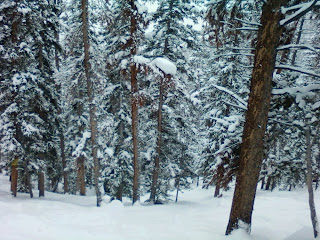
Day 23: Waist deep @ Keystone

This message has been sent using the picture and Video service from Verizon Wireless!
To learn how you can snap pictures and capture videos with your wireless phone visit www.verizonwireless.com/picture.
Note: To play video messages sent to email, Quicktime@ 6.5 or higher is required.


Wednesday, February 17, 2010


Tuesday, February 16, 2010
Wellington Lake is CLOSED!
Wellington Lake is a privately owned lake in the Pike National Forest, South of Bailey. The first year I moved to CO, I went camping here with a friend in September 06. I never knew exactly where we were at the time, and never gave it much thought to look it up. Finally today I was inspired, and it didn't take me long to find it on Google maps, and track down the name of the place.
Unfortunately, as of today, the website reads "Closed Indefinitely" and the message on their voicemail says that Wellington Lake is now closed to the public. Time to bid a sad farewell to some early CO memories - I was really hoping to be able to camp here again. I hope they are able to re-open in the future.
View Larger Map
Product Review: LaCrosse XG-55
Rating (out of 5): ****
Price: $60-99 USD (online)
I've acquired many pieces of outdoor gear this season, and I would like to share my experience with each of these tools both for my own reflection and for the benefit of others in the market. I have been looking for an altimeter for a couple seasons now, and my first review will cover my trusty new wrist-top aid, the LaCrosse XG-55.
To get us started, here's the key feature list from the box: altimeter, compass, barometer, chronograph, forecast, dual time/alarms, backlight, water resistant. The XG-55 comes in an attractive silver with black band and a red accent around the face, similar to many timex-style watches. Large, easy to use buttons make it simple to use with gloves on, the LCD brightness is great and the backlight is ample. The watch itself is a little bulky, but not uncomfortable or awkward.
The XG55 starts out with all your basic digital watch functions including date, time, day, altitude, temp, barometer, and forecast overlays all on the main screen. From here you can access alarm, chrono, and timer functions as well. Fairly intuitive, works like most other digital watches that I've used.
Pressing the Mode button moves you over to the barometer function, which can be calibrated to the current sea level pressure. The display shows both barometric pressure and temp, with the time in the lower sector. Holding St/Sp toggles the barometer reading between in/hg and mbar, and also the temp between F and C. Barometer has a 12 hour recall memory.
Out of the box I found the altimeter to be very accurate and quite useful. It reads in intervals of a foot (although it can also display meters)and also shows the time/temp overlay. This is a barometric altimeter however, so it is VERY susceptible to fluctuation based on local barometric pressure, and must be calibrated frequently if you want it to be accurate. Calibration isn't the most intuitive, so don't throw out the instruction book. Altimeter also has 12 hour recall.
Finally, the compass. This is a digital compass and best for approximations only. You can take a reading fairly well, however you usually have to take the watch off to get a good line of sight. It has an "off cal" indicator in case you are holding it tilted or are getting too much interference from metal around you, which is nice to alert you if the reading is wacky. Directions are given in NSEW and degrees, which make it nice to casually check a bearing while walking, but I wouldn't trust this thing over the standard compass in my pack for map reading and waypoint finding.
Overall I give it 4 stars. It lacks the high end features of a full function GPS watch, and is a little larger in form factor than some of its cousins, but for the functionality they pack in for the price, you can't beat it. The XG-55 is a great companion for the novice to advanced backcountry user looking for a capable, affordable wrist top.
Tech Specs
Actual Size: 2.12" x 1.38 " x 0.62"
# Altimeter Range: -2306 feet to 30,065 feet
# Barometer Range: 8.85inHg to 32.48inHg
# 5 Weather Forcast Icons
Compass Range:
# 0 to 359 (digital)
# 1 to 60 pointers (graphical)
Chronograph Range:
# 99 hours, 59 minutes, 59.99 seconds
# 100 Lap History
# Recall Lap History and Total Time
Timer Range:
# 99 hours, 59 minutes, 59.99 seconds
# Countdown Mode with Quick Set Values: 3, 5, 10, 15, and 45 minutes
# Timer sounds for 30 seconds when count reaches zero
# Thermometer Range: 14.0F to 140.0F (-10.0C to 60.0C)
# Water Resistant Case: Up to 100 Feet
# EL Backlight
# Watch Power Source:
# Single 3V lithium battery (CR2032)
Price: $60-99 USD (online)
I've acquired many pieces of outdoor gear this season, and I would like to share my experience with each of these tools both for my own reflection and for the benefit of others in the market. I have been looking for an altimeter for a couple seasons now, and my first review will cover my trusty new wrist-top aid, the LaCrosse XG-55.

To get us started, here's the key feature list from the box: altimeter, compass, barometer, chronograph, forecast, dual time/alarms, backlight, water resistant. The XG-55 comes in an attractive silver with black band and a red accent around the face, similar to many timex-style watches. Large, easy to use buttons make it simple to use with gloves on, the LCD brightness is great and the backlight is ample. The watch itself is a little bulky, but not uncomfortable or awkward.
The XG55 starts out with all your basic digital watch functions including date, time, day, altitude, temp, barometer, and forecast overlays all on the main screen. From here you can access alarm, chrono, and timer functions as well. Fairly intuitive, works like most other digital watches that I've used.
Pressing the Mode button moves you over to the barometer function, which can be calibrated to the current sea level pressure. The display shows both barometric pressure and temp, with the time in the lower sector. Holding St/Sp toggles the barometer reading between in/hg and mbar, and also the temp between F and C. Barometer has a 12 hour recall memory.
Out of the box I found the altimeter to be very accurate and quite useful. It reads in intervals of a foot (although it can also display meters)and also shows the time/temp overlay. This is a barometric altimeter however, so it is VERY susceptible to fluctuation based on local barometric pressure, and must be calibrated frequently if you want it to be accurate. Calibration isn't the most intuitive, so don't throw out the instruction book. Altimeter also has 12 hour recall.
Finally, the compass. This is a digital compass and best for approximations only. You can take a reading fairly well, however you usually have to take the watch off to get a good line of sight. It has an "off cal" indicator in case you are holding it tilted or are getting too much interference from metal around you, which is nice to alert you if the reading is wacky. Directions are given in NSEW and degrees, which make it nice to casually check a bearing while walking, but I wouldn't trust this thing over the standard compass in my pack for map reading and waypoint finding.
Overall I give it 4 stars. It lacks the high end features of a full function GPS watch, and is a little larger in form factor than some of its cousins, but for the functionality they pack in for the price, you can't beat it. The XG-55 is a great companion for the novice to advanced backcountry user looking for a capable, affordable wrist top.

Tech Specs
Actual Size: 2.12" x 1.38 " x 0.62"
# Altimeter Range: -2306 feet to 30,065 feet
# Barometer Range: 8.85inHg to 32.48inHg
# 5 Weather Forcast Icons
Compass Range:
# 0 to 359 (digital)
# 1 to 60 pointers (graphical)
Chronograph Range:
# 99 hours, 59 minutes, 59.99 seconds
# 100 Lap History
# Recall Lap History and Total Time
Timer Range:
# 99 hours, 59 minutes, 59.99 seconds
# Countdown Mode with Quick Set Values: 3, 5, 10, 15, and 45 minutes
# Timer sounds for 30 seconds when count reaches zero
# Thermometer Range: 14.0F to 140.0F (-10.0C to 60.0C)
# Water Resistant Case: Up to 100 Feet
# EL Backlight
# Watch Power Source:
# Single 3V lithium battery (CR2032)
Monday, February 15, 2010
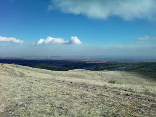
More Green Mountain - 4 miles with Lindsey

This is one of my favorite day hikes around the Denver area. If you start on Alameda Pkwy and head up past the radio tower at mile 1, your done with most of the vertical gain, and you can hit the 2 mile summit in around an hour depending on your pace. The overall gain is 700 ft, but there are some ups and downs which add to the actual gain.
On this trip we came back down the Green Mountain Trail, however there is a turnoff for the John H. Hayden trail (in blue) which offers a different view and a slightly more interesting (although a bit longer) hike for the return trip. Overall distance is ~4 miles.
View Green Mountain in a larger map
Once you make it to the radio tower you're rewarded with incredible views of the Denver plateau and the surrounding towns of Golden, Morrison and the hogbacks and flatirons. The city looks amazing from up here. If you continue on to the summit you gain an impressive and unobstructed view of the frontrange.


The quiver . . .

Back to front:
08 Burton Custom X 164w (non-ICS) - from the avalanche
04? Burton Canyon 164 w/ some old 04? Mission bindings
04? Burton Feather 151 w/ Ride LXh bindings (Lindsey's)
09 Burton Custom X ICS 164w w/ 07 Burton C02 bindings (my current weapon)
Saturday, February 13, 2010
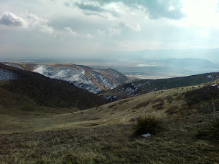
Day 21: Pow at Keystone - FINALLY!
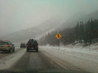

Our next run up the outback yielded open bowls. They were running the Cat but we didn't have any cash, so we hoofed it up the tracks to the outer part of the South Bowl past the gates. There was some sluffing along the ridge, but overall the snowpack was fairly stable. After dropping below the ridge, all I could do was lean back and float through the foot or more of powder that had deposited on the leeward side. This made for some good floating but tough turns. The traverse was gnarly and the catwalk out required that I point it the whole way to keep my speed up. Dom fell off the ridge behind me, lost a ski, and took more than 30 mins to reach the bottom . . .


Thursday, February 11, 2010
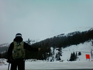
Day 20: Loveland Pass


Wednesday, February 10, 2010
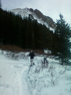
Day 19: Watrous Gulch & Keystone

I've seen this signpost before, although this time I'm headed off to the East up Watrous Gulch. Other than looking at the map, I'm totally unfamiliar with this hike, although it seems doable.
I got an early start by myself and hit the trailhead by 8am. I stayed on foot for a while, however a series of 6 ice falls over the trail forced me to shoe-up so I could use the crampons.
View Herman Gulch in a larger map
The initial climb is long, loud, boring, and relatively steep. You gain almost 1000ft in the first mile, and until you round the corner into the gulch you can hear I70 very loudly.


Monday, February 8, 2010
Lets go Avalanche!

Herman Gulch photos
Shoeing Herman Gulch. Photo taken near 11,200 ft.


Apparently we intruded a bird's comfort zone. He jumped down to about 15 feet away and decided to check us out a bit. He ended up about two feet from my head where this photo was taken with my phone, before we decided to move away and let this bird get back to being a badass.

Saturday, February 6, 2010
Day 18: Herman Gulch
View Herman Gulch in a larger map
Herman Gulch is in Arapahoe National Forest and the trail composes a section of the CDT or Continental Divide Trail. From the trailhead you head up a couple hundred yards to a fork - Watrous Gulch to the right, Herman Gulch to the left. There is a lake at the terminus of the gulch that is about 3.2 miles or 5k or so. The sign says 3.75 miles, but I think the winter use trail is slightly shorter because it doesn't wind into the trees, but stays in the clearing by the creek.


Day 17: Snowshoeing at Porcupine Gulch and more squirrels
Not sure what happened to my pics from this day - Mail2Blogger was acting up. Anyway, got an early start and decided to hit up porcupine gulch. Spent a good few hours hiking my way in and out tracking squirrel and hare. It was a cold morning and the animals seemed to be taking their time getting up.
The sun poked through at around 10am and I finally started hearing some birds and squirrel, but still hadn't seen a single animal. At 11am I was ready to give up, and as luck would have it, I found a squirrel in the tree where I left my bag! This could be the same one from the other day, and I decided to tag him. Overall a successful and fun morning, although I bailed on making turns because I was tired and it was getting late in the day.
View Porcupine Gulch in a larger map
Friday, February 5, 2010

Wednesday, February 3, 2010
Hayden/Green Mountain Park
View Green Mountain in a larger map
I've done this hike a few times but attacked it a little differently this time. First, I was using my new SwissGear alpine hiking poles ($25 on sale at Big 5!) which were great - I won't hike without them now. Also, I ran this one solo and decided to hoof it to the summit. I took the standard Green Mountain trail up, but decided to take the fork to the John Hayden trail just before the radio tower on the way down. I hadn't used this trail before, and it was a nice break from the routine. It is a slightly longer and more challenging trail, and it offers a slightly different but equally as impressive view for the way back.

Day 16: Snowshoeing, Squirrels, and A-Basin

As I was leaving the gulch I decided to sit for a while and let the woods settle, hoping I could see some animals. After about 25 mins sitting just out of earshot of the road near a squirrels nest, and not seeing anything, I was ready to give up. Then I heard the bark! First a single chirp, then aggravated screaming barking so loud that it made me jump - you guessed it, Chickaree! Freaking pine squirrel didn't like me near his tree and he sat there, staring me in the face, BARKING FOR 30 MINS. I've heard these guys don't back down, but jeez. The most incredible display of fearless territorialism I've ever seen - and from a 2lb squirrel!


Subscribe to:
Posts (Atom)